Ross Eccles
artist - architect - concepts designer
creative thinker since 1937
4.2.
SHANNON TO DUBLIN
Ship Canal

Shannonsuperhighway
Shannon/Dublin Ship Canal - Route Map
www.shannonsuperhighway.com/shannon-dublin-ship-canal
Introduction
The Grand and Royal Canals linking Dublin with the Shannon Navigation, are triumphs of 18th Century engineering. Designed for the transportation of goods and passengers by horse-drawn craft, they have found a new use as "leisure corridors" for pleasure boating, angling, cycling, walking etc. Although transportation by waterway is efficient and environmentally friendly, these small scale Canals, are quite unsuited to modern Inland Waterways goods transportation.
Ross Eccles Concept Proposals for a New Shannon/Dublin Ship Canal, are based on current EU Inland Waterways Class Va Standards. (Craft up to: 3000 tonnes, 110m length, 11.4m beam, 5.5m draft & 8.8m air clearance).
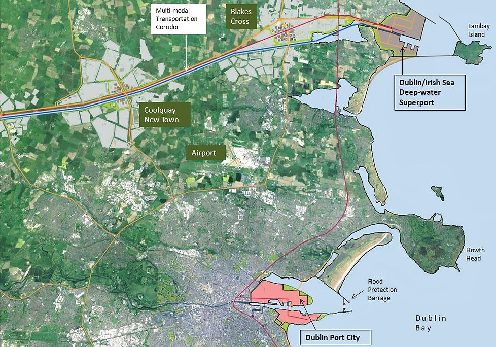
The Canal forms the spine of a multi-modal "Innovations Corridor" stretching from an East Coast SuperPort to Athlone.
Canals formed the backbone of the Industrial Revolution in the Midlands and North of England. Likewise, Ross believes that this proposed Canal, alongside a road, rail and integrated services corridor, could form the "backbone" of a Linear nodal City stretching from Athlone to Greater Dublin.
Integrated thinking is common practice in other jurisdictions. Integrating projects and services in a planned manner, eliminates the economic waste associated with funding isolated and uncoordinated infrastructural projects.
For example: The Canal will be filled with a large volume of fresh water and, locks require return pumping. An opportunity arises for Irish Water to transfer water from the Shannon to Dublin by extracting water from the canal as required. The €1.3 billion capital cost and public perception problems, associated with constructing a pipeline from Parteen Basin to Dublin will be removed. A contribution to the Capital Cost of the canal could be made by Irish Water and other interested Parties. A major part of funding may be available through the EU's TEN-T programme, particularly in view of the special circumstances created by Brexit.
The Canal is designed to link up with a Proposed deep-water SuperPort in North County Dublin. This SuperPort is designed to accommodate E Class Container Ships sailing directly from The Far East etc. It will allow direct links with other deep-water ports such as Zeebrugge without the necessity of trans-shipping goods on to smaller vessels, or through Britain, where custom delays and tariffs threaten. It will replace the existing commercial trade in Dublin Port which, operates at serious cost disadvantage due to shallow depth and other logistical inefficiencies. Cruise vessels will continue to dock in Dublin Port, in a vastly improved environment once commercial shipping and associated unsightly infrastructure are removed.
The Proposed Location of our Concept Deep Water Container Port, is between the Rogerstown Estuary and Lambay Island in North County Dublin. It is close to the Dublin to Belfast road and rail links, which could be extended to serve the Port. The Canal terminates at the SuperPort as indicated on plans below.

Shannonsuperhighway
The Grand Canal at Shannon Harbour

Shannonsuperhighway
New Ship Canal - Proposed Route Map

shannonsuperhighway
Proposed Canal Dimensions

Shannonsuperhighway
Utilising the Canal for Irish Water
www.shannonsuperhighway.com/shannon-dublin-ship-canal

Shannonsuperhighway
Atlantic/East Coast Navigation Route-
